This article covers 5 free tools to create interactive maps online. With these tools, you can create custom digital maps which you can share with others online. You can visit any desired location on the world map and start annotating it with various options to create a custom map. You can create paths, boundaries, checkpoints, and even embed media in some cases.
Each of these tools has a different take on creating an interactive map. Some of them are to create a regular but interactive digital map where you can draw and mark places on different types of map-topologies and export the results. Wheres, some focus on a story map where you can express a story through an interactive map. And, one tool is quite unique that lets you create custom maps with real-life data layers on top like carbon emissions, human footprint, surface temperature, population, etc. So, let’s dive in the article and check out these tools one by one in details.
Also read: Best Interactive Universe Map To Know How Big Is The Universe
5 Free Tools to Create Interactive Maps Online:
Google My Maps
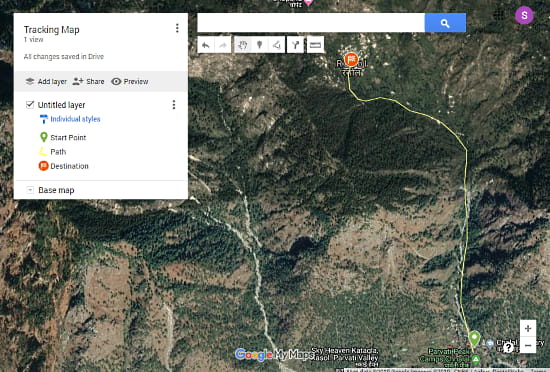
Google’s My Maps is a free online service to create custom maps. If you used Google Maps or Google Earth before, you would find this service very similar to those. In My Maps, you can create custom interactive maps for any location on Earth. You can location marks, draw paths with the line tool, add walking, biking, and driving route. Everything you add to the map gets listed in the map info panel present at the top left side of the screen. You can rename it from there to best suit your custom map and also include photos and videos. Similarly, you can add multiple layers to add more data to your map and can also change the base map topology to any of the given options.
The map is automatically saved to your Google account every time you make a change. And, you can also export it to a KML or GPX file at any time. This custom map appears in Google Maps mobile app where you can download it for offline use. Apart from My Maps, you can also use the Google Earth application to create interactive maps. For that, you can read my other post explaining how to create custom maps with Google Earth which you can export as KML/GPX files and import to Google Maps as well.
Create interactive maps with Google My Maps here.
ScribbleMaps
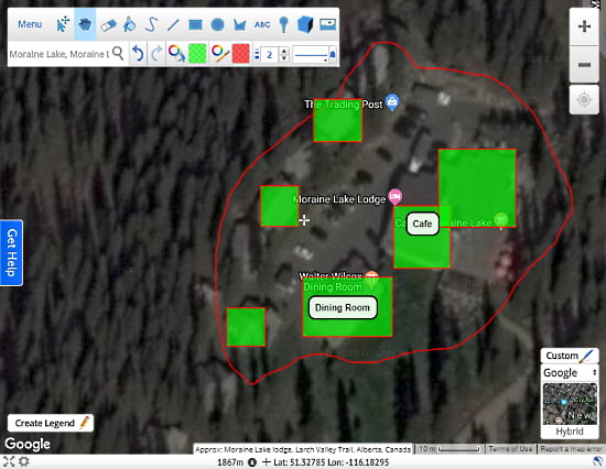
Scribble Maps is another online service to make interactive maps. This service works similar to ‘My Maps‘ but with more features and without creating an account. This service gives you comparatively more drawing options which you can use to select, mark, highlight, and annotate the map. Here, you get options to not only choose a custom color but also define color transparency and width of the drawing tools.
This service offers various topology options with custom labels, geometry, and color along with advanced options to add lightness, saturation, hue, gamma, weight, select visibility and elements to show. You can create map legend for guidelines and add multimedia files as well. Once done, you can export the map as an Image, PDF, KML, GPX, SHP, DXF, CSV, or GeoJSON file. This service also has a paid-tier with features like KML import, geocode import, groups, heatmap, analysis, transformation, bulk operation, custom filters and more.
Make digital maps with ScribbleMaps here.
NatGeo Mapmaker
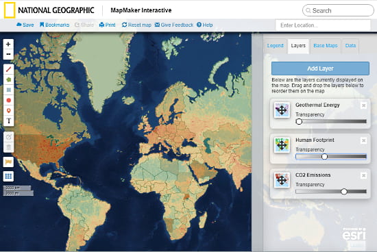
NatGeo Mapmaker is a unique service that lets you create custom informative maps for free. Similar to both above-mentioned service, it has a decent set of drawing and labeling tools to help you build a custom map with legend and various topology options to go with. The main highlight of this service is the layers. This service offers dozens of data layers which you can add on top of a map to visualize respective information. Here is a list of data layer categories this service offers:
- Water
- Earth Systems
- Climate and Weather
- Human Populations
- Environment
- Energy
- Animal Ranges
- Culture
- Economy
- Political Boundaries
- Food
- U.S. History
Each of these categories has multiple data layers like Hydroelectric Energy, Land Cover, Ocean Surface Currents, Surface Temperature, Biomass Biowaste Energy, Human Footprint, Internet Users, Women in Parliament, Rice Production, Potato Production, African American Population, and a lot more. You can add one or more of these layers on the map and adjust their opacity to create a nice visual. Once done, you can save the map by mentioning your email address and get an email with a link to the map. You can also print the map to PDF and share it via its unique URL.
Create online interactive maps with NatGeo Mapmaker here.
StoryMap JS
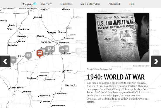
As the name suggests, StoryMap JS is a free online tool to make map-based stories. This tool gives you a simple world map (no topology) where you can create an interactive story map. You can mark a location on the map and create slides with photos for an interactive tour. Apart from the photo, this tool gives you various options to add other types of content to the story map including online videos, songs, etc. On top of that, you can create a heading for each location and add a paragraph for the story.
Once the map is complete, you can preview it and publish on the StoryMap website. After publishing the story map, you can share it with others using the map URL. The story map runs in the form of slideshow covering each marked location at a time showing the embedded media and the story.
Create interactive story maps with StoryMapJS here.
ESRI Story Maps
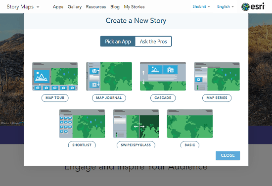
Last but not least, ESRI Story Maps is another free tool to create interactive story maps online. This tool serves the same purpose as of ‘StoryMap JS‘ but with more features and topology options. It lets you create a story map by combing photos and locations along with the text. The story map is played as slides covering each added location one by one.
The thing where this tool is different from the other story map tools is templates. This tool offers you various templates for the story maps. Here is a list of all currently available templates which you can use to create story map:
- Map Tour
- Map Journal
- Cascade
- Map Series
- Shortlist
- Swipe/Spyglass
- Basic
In case you are having a hard time picking a template, you can take a small survey to figure out the best map template for your story. Once finished, you can save the map to your account and share it with others with its unique URL.
Make stunning Story maps with ESRI Story Maps here.
Closing Words:
These are the 5 free tools to create interactive maps online. Each of these tools has its own unique set of tools with unique features. Selecting one is totally depends on the use case. If you want to create a map for navigation purposes then go with Google My Maps or ScribbleMaps. If you need an informative map then try NatGeo Mapmaker. And, if you are interested in story maps to showcase your trips, then give StoryMap JS or ESRI Story Map a try.