In this article, you will read about how you can explore realtime satellite images of Earth, Storms, and Wildfires with Zoom Earth.
If you love to explore the satellite imagery of the Earth from various online platforms, then you must be collecting most of the imagery from either the NASA website or Google Earth. Just like many people out there, I also used to search the satellite imagery from these two platforms only.
However, I’ve recently discovered a web application that lets you explore the realtime Earth images while you can simultaneously zoom in to see the surface, storms, and wildfires. This web application is called Zoom Earth. This is a free platform where you can have an experience like Google Earth but with real satellite imagery.
Explore Realtime Satellite Images of Earth, Storms, Wildfires: Zoom Earth
Zoom Earth is a free web application that lets you explore the near-real-time satellite images from different satellites that you can zoom in to explore the earth’s surface, storms, and wildfires across the Globe. Let us see how.
For this, you can visit the website by copying and pasting the web address https://zoom.earth/ in your search tab, or simply click here to visit the website.
There, you will see the part imagery of Earth Surface, in which you can see the current wind and storm situation in an area of the Earth. As you hold and move around the surface, you can clearly which part of the earth is currently under the sun (as in daylight) and which is not (as in nighttime).
Contrary to the other applications, such as Google Earth, where you can rotate the Earth via mouse/trackpad, this web application shows you the picture of the Earth in plain imagery.
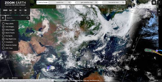
Moreover, you can choose which information you want to see on the image, such as map labels, fire spots, day-night line, UTC time, etc. This you can do by simply navigating on the menu bar presented as the three horizontal lines in the top left corner below the Zoom Earth time information.
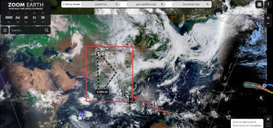
Apart from this, you can also measure the distance as well as the area by choosing the option from the bottom right corner for the shapes (line, and square). By clicking on the line, you can measure the distance and by choosing the square, you can navigate on the map and choose which area you want to measure.
There you have it, feel free to explore the earth imagery with this application.
In brief
Zoom Earth is a lot like satellite imagery from in a way but you also interactive just like Google Earth. The one thing that gives this web application an edge is its near-real-time satellite image update. And the best part is, you can zoom in and out to see your location with clarity. You can see the images which are only a few hours old, so you can track the storms, wildfire, and explore much more with Zoom Earth.