In this article, I will cover 4 free online cartogram maker websites.
Cartogram is a thematic map that shows statistical information on top of the geographic location. A cartogram can be used to show various types of information such as population, travel time, travel map, etc. The geometry of the map can be distorted to convey the information of alternate variable.
Here are 4 online cartogram maker websites. With these websites, you can easily make cartogram within minutes. Most of these websites offer world map whereas some are limited to US & Europe map only. After making the cartogram, you can tweak its appearance and download the final map. So, let’s check them out.
Also Read: 8 Online Heat Map Generator Websites Free
Here Are 4 Free Online Cartogram Maker Websites:
Tilegrams
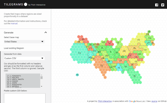
Tilegrams is a free web tool to make cartogram online. This tool generates cartogram with regions proportional to the dataset. It has following base maps which you can use to represent your data:
- United States
- Germany – Constituencies
- France – Regions
- France – Departments
- Netherlands
- Brazil
- Ireland
This tool offers a few general datasets built-in which you can use and personalize as per your needs. To create a new cartogram, you can paste the CSV data here and it will plot that data on the selected base map. Tilegrams uses tiny colorful tiles for the map and gives you an option to change the tile density for the map. After making the cartogram here, you can download it as a TopoJSON file or SVG file.
Give this online cartogram maker a try here.
Heatmapper.ca
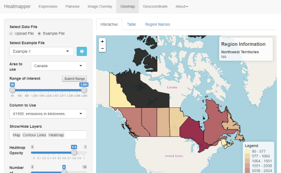
Heatmapper.ca is a free website with free interactive data visualization tools with a worldwide map. You can create various types of data visualization maps including cartogram on this website. It offers five tools to generate different types of maps out of which the following three can be used for cartogram:
- Image Overlay: A map of densities is displayed based on values at plot coordinates corresponding to an image.
- Geomap: A choropleth map is displayed specified by values assigned to locations based on political boundaries.
- Geocoordinate: A map of densities is displayed based on values assigned to locations specified by latitude and longitude coordinates.
Based on your dataset and needs, you can use any of these tools to make cartogram here. To do that, simply select the tool you want to use and upload your dataset as a TXT, DAT, TSV, TAB, CSV, or Excel file. As you upload the dataset, this tool plots the information on the map and gives you a handful of options to tweak the map. After finalizing the map, you can download it as a PNG, JPEG, TIFF, or PDF file.
You can try this online cartogram maker website here.
OpenHeatMap.com
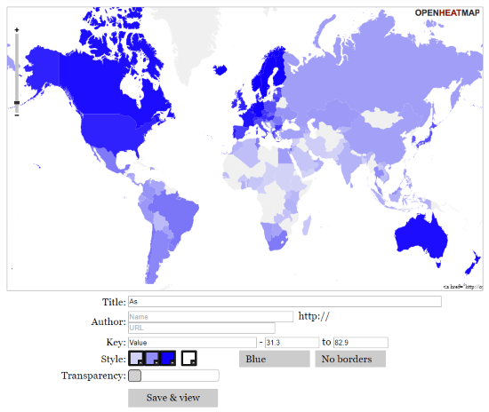
The next website to make cartogram online on this list is OpenHeatMap. This is a free web application to make heatmap online which can also be used to create cartogram on a worldwide map. You can easily make cartogram here within two simple steps. The first step is to upload your dataset. You can upload a CSV or Excel file with your dataset or fetch a dataset file from Google Docs.
After uploading the dataset, simply click “View on Map” button to make the cartogram. This will show your data on the map. This application offers a few customization options that allow you to change the colors, transparency, and size of the data visualization. After making the map, you can add a title, author, and key value to the map and save it with a permalink which you can use to share it with others. You can also generate an HTML embed code to the map on webpages.
Give this online cartogram maker a try here.
NatGeo Mapmaker
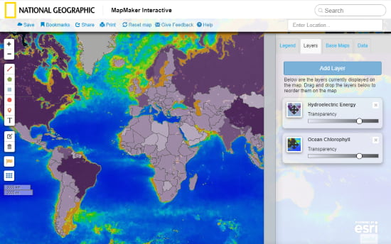
NatGeo Mapmaker is a free online tool to make interactive maps. You can use this tool to create cartogram online. This tool packs 7 base maps (world map); you can choose any of them for your cartogram. It doesn’t give you an option to upload your own dataset but it has a toolbar that you can use to add layers on the map. On top of that, it offers dozens of dataset layers covering the following categories:
- Food (11)
- Climate and Weather (7)
- U.S. History (3)
- Water (6)
- Earth Systems (6)
- Human Populations (12)
- Environment (14)
- Energy (9)
- Animal Ranges (13)
- Culture (2)
- Economy (5)
- Political Boundaries (1)
If you need any of these datasets in your cartogram, you can simply add them from the layers. Otherwise, you can create your own custom map using the drawing tools. After making a map, you can save it to generate a permalink. You can also save it as a PDF file using the Print option.
Make Cartogram online with NatGeo Mapmaker here.
Wrap Up:
These are the 4 free online cartogram maker websites. Depending on your dataset and requirements, you can use any of these websites to make cartogram. Go ahead, give them a try and share your thoughts with us in the comments.