This article covers a free online service to scan large geographical areas to find similar places. The name of this service is TerraPattern. It is an open source visual search tool for satellite imagery where you can select a location on the map at it will find similar visual locations in the area. It is good for finding intersections, parks, fields, building, etc.
In the results, it marks all the similar locations on the map and lets you export the result data as GeoJSON file. If you are interested, you can check out the source code of this service on GitHub here.
This service can have great significance for scientific, culture, humanitarian, and sociological researchers. So, let’s check it out how it works and which features it offers.
Also read: How to Find Geo-Based Creative Commons Images Based on Location
Scan Large Geographical Areas to Find Similar Places: TerraPattern
Find similar places with TerraPattern is simple and straightforward. All you have to do is choose a city, select a location, and get similar locations in the results.
Supported Cities:
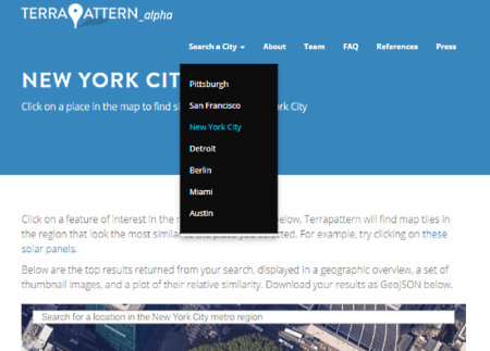
As of now, this service only supports a handful of cities of the United States. Here is a list of all the supported cities:
- Pittsburgh
- San Francisco
- New York City
- Detroit
- Berlin
- Miami
- Austin
From the homepage, you can select any of these cities and run your inquiry to find similar locations.
How To Search:
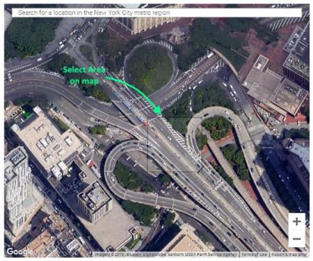
To find similar visual locations, select the city and find the location which you want to use as the source location for comparison. You can find a location manually on the map or enter the location name to search that quickly. Once you have the source location, hover your mouse cursor to find a suitable area and click it to start the search.
Search Results:
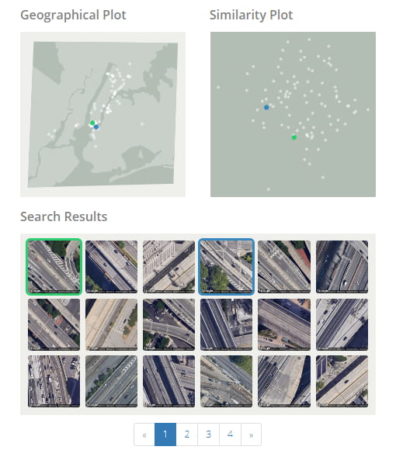
This service gives you the results of your inquiry within a few seconds of search. In the search results, it finds all the visually similar location in the city and shows you the pictures. You can tap on any picture to view that on the map. Along with that, TerraPattern shows you two plot views for more information:
- Geographical Plot: Shows a small map of the city with all the similar locations marked on it.
- Similar Plot: Shows all the similar location on a plot grouped by similarity level.
In the end, you can export the search result data as a GeoJSON file which contains information about the locations with geometry details.
Scan geographical areas to find similar places here.
Closing Words:
TerraPattern is a nice web service to find similar locations which are usually not mentioned on the map. It can be really useful for study and research purposes to quickly find similar visual features in a city.