MapHub is a free online application to create interactive maps with lines, tracks, polygons, points, and labels. You can choose various basemap (means background for your map) for all your customized and interactive maps. It offers 20 different basemaps including classic, streets, outdoors, satellite, transport, landscape, and more. MapHub lets you search for places or you can simply move & zoom the map around to find out any location. Similar to other websites such as Animaps and MapMe, this one also lets you add pinpoints, lines, tracks, polygons, and text labels to the maps.
To create an interactive map, all you need to do is add items like points, polygons, etc. and give your map a name, add a description, add a URL name, and set the visibility (either as public or private). You can also insert various symbols to the added items, change colors, add co-ordinates, etc. Once, you’re done with creating a custom map, you can simply use the unique URL to share the map with other. It also allows you to export and import files as GPX, GeoJSON, and KML formats.
Note: According to the developers, some news features like collaboration, viewers control, and editing privacy will be added soon to MapHub.
How to Create Interactive Maps with Polygons, Tracks, Labels, and Points:
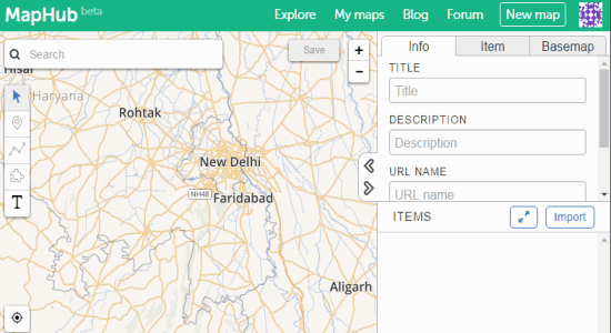
Step 1: Visit the homepage of MapHub and sign up with your email and username. Once you’re in, hit the “New Map” button at the top. The editor will open up with the blank map canvas. You will also see options like the search function, items toolbar, basemap selector, etc.
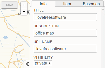
Step 2: To create an interactive map, the first thing you need to do is fill up the info part of the map. Click the “Info” tab on the right and give your map a title, add a description, custom URL name, and set visibility to public or private.
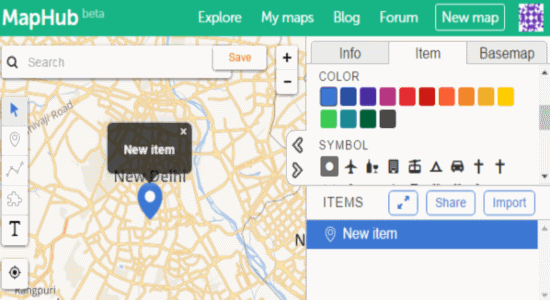
Step 3: After that, search for any places or move & zoom the map to find out a particular location. On the left, there will be a toolbar from which you can add items like a pinpoint, a line or track, polygon, and a text label. Select an item and click on the map to add it. To customize any item, select the item on the map and go to the “Item” tab on the right. You will be able to add descriptions, change item color, add symbols & co-ordinates (for points), etc.
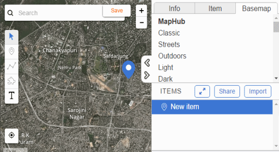
Step 4: Now the interesting part is that you can choose different basemaps for your custom maps. Actually, a basemap refers to the background of the map. There are 20 basemaps including streets, satellite, etc. and are listed in different categories like MapHub, Mapbox, ThunderForest, etc. Click the “Basemap” tab adjacent to the “Item” tab and choose your favorite background.
Step 5: Once, you’re done with adding items to the maps and creating an interactive map, simply click the Share button on the right to fetch the unique URL to share the map. All the created maps will be available on “My Maps” tab at the top.
Step 6: If you wish to import existing files or export created files, then it also has the options to do so. You can import and export files as KML/KMZ, GPX, and GeoJSON.
My Final Verdict:
MapHub is a simple and useful online application that lets you create, customize, and share interactive maps. You can add points, polygons, lines, tracks, and text labels to all your maps. Use the search function to search places or simply drag the map and zoom it to find out any location which you want to include in the map. To make your maps more interactive, it also offers various basemaps including streets, satellite, etc.