This article covers a free interactive wildfire map to view global fire statistics. The instances of wildfire have been increased all around the world over the past few years. Most of the time, there is a human mistake behind a wildfire. And many people also blaming global warming for an increasing number of wildfires. Whatever the reason is, wildfires are dangerous and have a negative effect on our planet. Wildfires have destroyed forests, agricultural lands, and houses polluting the air quality, increasing carbon emission and affecting thousands of lives.
GlobalForestWatch.org provides an interactive wildfire map where you can view the global fire statistics. This interactive map shows all the reported wildfire and other domestic fire incidents all over the world. With this map, you can view all the fire instances reported in past and track active fire incidents happened in the past week.
Apart from the fire, you can also view the statistics of air quality, land covered, and weather affected by the fires. This map can also generate a fire report for a selected region and calculate fire counts on a specific location with fire alerts via email or text. It also offers high-resolution satellite imagery of wildfires which you can view on top of various topology.
Also read: Interactive Climate Change Map to Visualize Climate Impact
Free Interactive Wildfire Map to View Global Fire Statistics
GlobalForestWatch.org provides a database of reported fire incidents happened and currently happening all over the world. All that data is mapped on an interactive world map where you can track the fire incidents along with affected land, weather, and air quality.
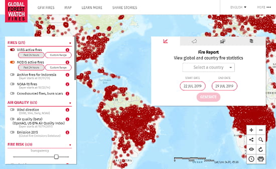
This map visualizes the fire incidents with red color and has two information panels on each side. The information panel on the left helps you track the fire incidents and their impacts whereas the panel of the right generates fire reports along with options for fire alerts and change the map topology and imagery. You can hide these panels with the options given at the bottom right corner of the map. From here, you can also print the current map on the screen to PDF.
Interactive Map to Track Fire Incidents
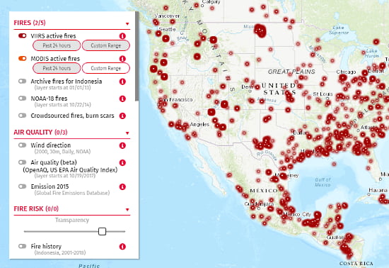
From the left side information panel, you can visualize the following data on the map and gather statistics:
Fires
- VIIRS active fires (track stats of past 24 hours or a custom range up to 7 days)
- MODIS active fires (track stats of past 24 hours or a custom range up to 7 days)
- Archive fires for Indonesia (track stats for custom data range)
- NOAA-18 fires (track stats for custom data range)
- Crowdsourced fires & burn scars
Air Quality
- Wind Direction (on selected date)
- Air Quality (on selected date)
- Emission 20115
Fire Risk
- Fire History (for a selected year)
- Days since last rainfall (on selected date)
- Fire Weather (on selected date)
Land Use
- Forest moratorium (Indonesia)
- Concessions
- Oil palm
- RSPO oil palm
- Wood fiber
- Mining
- Greenpeace Concessions
- Managed forests
- Oil palm
- Wood fiber
- Selective logging
Conservation
- Protected Area
Land Cover
- Peatlands (2000, Indonesia)
- Tree cover density (2000, Hansen/UMD/Google/USGS/NASA)
- Primary forests (2000 – 2012, 30m, Indonesia)
- Plantations
Stories
- Fire stories
The right-side information panel contains two important feature of this map; Fire Report and Fire Alerts.
Fire Report
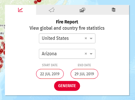
With the Fire Report feature, you can generate a fire report for a specific state or region of a country and view the local fire statistics for a custom date range (generally past month or so). The fire report shows you all the fire incidents happened in that area in details covering
- Distribution of fire alerts on a map
- Greatest number of fire alerts by provinces and districts
- History of fire alerts in that area on a graph
- Fire seasonal progression
- Annual fire history
- Unusual fire history
Fire Counts and Alerts
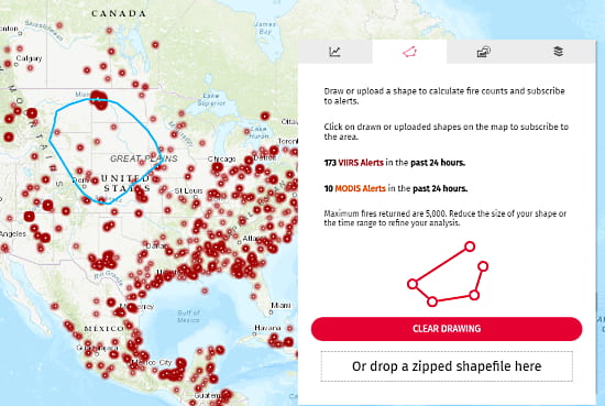
Fire Alert feature lets you draw a shape on the map and lets you enable alerts for that. For fire alerts, you can either mark the area on the map or load a shapefile with location data. It shows you the fire alerts of that area in the past 24 hours and lets you activate email or SMS fire alerts. When activated, whenever a fire incident is reported in that particular area, it notifies you by sending a fire alert message.
Along with all the statistics, this map also provides high-res imagery and supports various base maps. In this map, you can view the following high-res imagery:
- Planet Basemap
- DigitalGlobe
- Sentinal Imagery
Along with the imagery, you can also change the base map and view the fire incidents by Provinces, Districts, Subdistricts & Villages. This map offers the following base maps:
- Dark Gray
- Topo
- WRI
- Imagery
- OSM
- LandSat
View global fire statistics with interactive wildfire map here.
Wrap Up:
This interactive map offers a great deal of information on wildfires and domestic fires. The fire alert feature comes handy to get an alert whenever there is a fire incident in the area. Having a global database of fire incidents, it is good for research and academic purposes as well. With this map, you can not only track the fire incidents on the map but can also generate an information-rich fire report covering various statistics related to fire.