Sygic is a free iPhone app for offline GPS navigation with 3D maps, POI’s, turn-by-turn voice navigation, route planning, etc. It only uses iPhone’s GPS and provides high-quality offline maps which you can use without any internet connection. For navigating to a particular location, you can either search that location using Sygic or by importing a photo from your camera roll. The photo part sounds interesting isn’t it, do not worry I will explain it now. When you import a photo to Sygic, it uses the details (meta-data) of the photo to track the location, where the photo was taken and then navigate you to that location. It has tons of point of interests (POI’s) pre-installed for each map, or you can also search for the POI’s by area zip code or using Google’s search. The best thing about Sygic is that it shows 3D surroundings (maps) of any location for easy navigation.
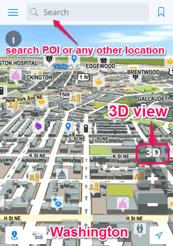
The following screenshot shows the offline 3D map of “District of Columbia” (Washington).
Sygic is probably one of the best iPhone apps for offline GPS navigation with offline maps and free map updates. Simply download maps for different countries and locations to enjoy GPS navigation without internet connectivity. Choose a start and an end point and start navigating with 3D buildings/landscape for easy orientation of the map. You can also tap on any area of the map to get GPS coordinates, nearby POI’s, directions, etc. of that particular area. The most interesting thing about this app is that it provides offline maps for over 110+ countries absolutely free. The countries included are United States, United Kingdom, Brazil, India, France, Italy, Australia, and many more for which offline maps can be downloaded.
How to Use this iPhone App For Offline GPS Navigation:
Download this excellent offline GPS navigation app from the App store or from the link provided at the end of this post.
Download offline maps for navigation:
After installing the app, choose between different regions and download the appropriate map for navigation. As soon as you download the map, simply start exploring the map without internet connectivity. Initially, the map will be in 2D mode, but with a single tap you can enable the 3D environment of the map, as shown in the above screenshot.
Search or enter any location to start navigation:
You can navigate to any destination by using different methods. The methods are as follows:
- Use the search bar to navigate through different locations. Simply type names or GPS coordinates of any location to start navigating.
- Tap on any area of the map to see the name or address of that area. As soon as you tap on any area, you can get directions or route to that particular area for navigating.
- This method is the fastest one, as you can simply tap on previously saved location and start navigating. Save locations as your favorite or contacts. You can also use navigation history for easy access of locations. You can assign any location as your home or work destination for easy access.
- Photo navigation is the advanced feature of Sygic. Simply import any image from your camera roll, then Sygic will use the description (tagged location) of the image to track the geographical location of the place where the photo was taken. After that, you can start navigating to that location.
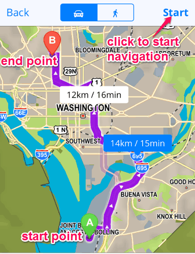
Start navigation by defining start and end-point:
When the start point and end point is defined using the above methods, simply start the navigation and the route (source to destination) will be highlighted with violet color. Sygic will also display the distance as well as the time required to reach the destination. The below screenshot shows the navigation from start-point A to end-point B.
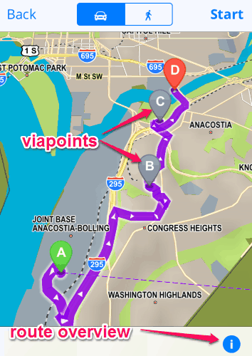
Add via point and view route overview:
While you are navigating from point A to point B, you can add multiple via points and view the route overview. Add via points by simply tapping and holding on any location between point A to point B. When you hold on any location, a Blue blurry icon will appear, which can be used to assign different via points. It also lets you view the route details, like POI’s, streets, sharp turns, etc. The following screenshot shows how to assign via points and how to view route details.
This app offers tons of useful free features but includes some advanced features as well, which require a single in-app purchase. The paid features are HUD projects, traffic services, speed cameras, Overspeed warning, etc.
We have also reviewed 5 Free Navigation Apps For Android.
My Final Verdict:
Sygic is a very useful and efficient offline GPS navigation app for iPhone. You can download maps of over 110+ countries for offline navigation. To make the orientation of the map easier, you can use 3D environment feature. It supports turn by turn voice navigation, route planning, tons of pre-installed POI’s, etc. Honestly, I think this app is very intuitive and provides one of the easiest ways for offline GPS navigation. Try this app for once, you would like it for sure.
Get the app from the link here.