F4 Map is an Interactive 3D Map Viewer based on Open Street Maps (OSM) which is an collaborative mapping project by a community of volunteers. The maps are replete with aerial imagery that displays accurate geo-localized in a 2D or 3D environment.
F4 Map uses WebGL for rendering the images. WebGL is a JavaScript technology used to render interactive 2D / 3D graphics on any browser without using any other plugins.
The application has been developed by a company with the same name – F4 which was founded in 2002 and specializes in 3D and similar digital applications for business and general use of the public.
Features:
- Geo-localized content: F4 map displays precise geo-localized content like buildings, shops, road / rail networks, services, places of interests and much more.
- Custom Content display: A viewer may choose the type of content that he wants to visualize in the map based on his requirements and areas of interest.
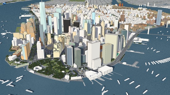
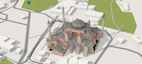
- 3D modelling: F4 Map provides 3D models of popular and historical buildings and other structures along with geographic Elevations with a high level of accuracy.
- Real Time display – You can view day and night effects, current position of the sun, dynamic shadow generation, local weather etc. in real-time.
- 3D Animations: You can produce realism and life in your map by using animated rain, snow, waterways, real-time water reflection and more.
- Fast Search: Quickly access any kind of content stored in the OSM database using the search tool
- Collaboration: You can easily enhance and augment the map with your own content and knowledge of local areas using openstreetmap.org or the Wiki of F4 Map (wiki.f4map.com/) if you are an authorized user.
F4 Map is an ideal solution for Business and Trade establishments to enrich their services and provide a drive-to-store experience to their customers. Event Managers can use it to generate and publish amazing maps for the events that they organize. Tourism buffs can use F4 Map to create interactive maps depicting the history and heritage of chosen areas. There is virtually no limit to the number of customized map solutions that you can develop and launch.
How it Works:
1. Navigate to F4 Map using the link that we have provided at the end of this article. No registration or sign in is required if you simply want to view the maps.
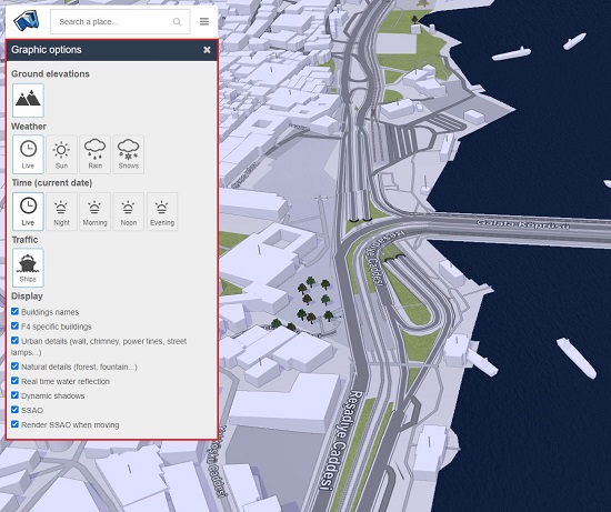
2. Click on the 3-lines icon beside the search box and then click on ‘Graphic Options’. This will display a popup box from where you can select / deselect the Content and Features that you wish to view in the map such as Ground elevations, Weather (Sun, Rain, Snow etc), Time (day-night effects), Urban details (walls, power lines, streetlamps etc), Natural details, Dynamic shadows and more.
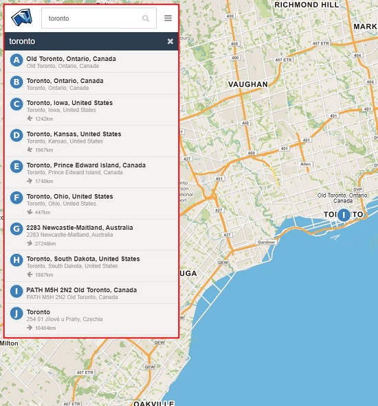
3. Click on the search box at the top left of the screen, type the name of any place or location and press Enter or click on the magnifying glass. A set of results will be displayed depending on the place that you have searched. Click any one of the results and this will take you to the specified location and display it in the center of the map along with the content and features that you have selected above in the previous step.
4. To zoom in / out of the map, use the scroll wheel of your mouse or the + / – buttons available at the top right of the screen. 3D view will be enabled only if you zoom in till 5 km above the surface of the earth as indicated at the bottom right of the screen. When 3D view is enabled, a checkbox will be displayed at the top right using which you can toggle between 2D & 3D views. Elevation and building models will be visible only in the 3D view if you have chosen to display them in the graphic options.
5. To pan the map, click on any area and drag the mouse wherever you desire. Once 3D view is enabled you can click the right button and drag the mouse to tilt the view (change the viewing angles) as well as rotate field. You can also click and drag the compass ring at the top right to rotate the map.
6. If you are an authorized user and interested in editing Open Street Maps, click on the 3-lines icon next to the search box and then click on ‘Edit via OSM’ or ‘Edit our Wiki’.
Closing Words:
F4 Map is a good tool to view Open Street Maps interactively on any browser without using plugins. The interactive view looks and functions quite impressively except for the fact that the response times are slow and sometimes the certain areas do not refresh at all giving rise to broken views. Elevation of many buildings seems to be incorrect, but this is also possible since all the data is coming from OSM which is open-source and can give rise to errors and omissions. Sometimes it feels as if F4 Map has just taken the floor plan data and assumed that every building has the same elevation as all of them look identical. Overall, apart from some aspects of the UI / UX this seems to be a neat and interactive map viewer.
Go ahead and navigate to F4 Map by clicking here.