This article covers an online farm mapping tool to create descriptive farm map. Farmapper is a cloud-based mapping application specifically designed to create descriptive farm maps. With this app, you can create a custom map of your farm by visiting the exact location on the map. It is powered by Google Maps which provides Satellite and Map view of the land. You can map your farm on the map, create sections, add information with stickers and fetch legal description of the land and create a crop scope layer as well. Upon creating an information-rich farm map with all that data, you can export in the form of a KML file. The map is saved to your Farmapper account as well.
The free-tier of this app lets you create a single project with a maximum data limit of 1 GB. You can check out this application in the free-tier by creating an account. And, if you want to bypass the limitation, you can go with any of the three paid-tiers which let you create more projects with more storage.
Also read: Free Farming Simulation Game Without In-App Purchases: My Land
Online Farm Mapping Tool to Create Descriptive Farm Map
Creating a map of your farm is simple with Farmapper. First, you have to create an account obviously and then you can start mapping your farm by creating a project. The project screen contains two sections, one for the information and one for the map. The information section is for all the description you want to add and the map section is to show your farm on the map. Let me break it into simple steps to make it easy to grasp.
Tracks

After creating a project, you can simply start marking your farm on the map. The top section of the map contains mapping tools which you can use to mark your farm area. As soon as you are done marking an area, it got added into the tracks containing information like total area, coordinates, etc.
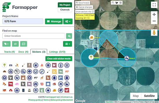
This app also has a wide range of stickers that you can use to mark various sections of your farm along with the text. Also, there is a crop tool at the top which you can use to measure land area and to cut out area from the farm.
Legal Description
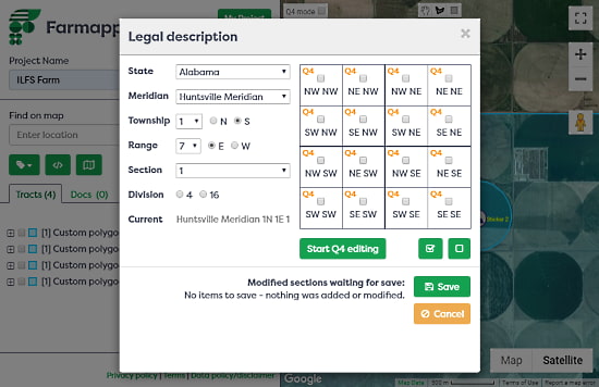
The Legal Description option fetches the legal data of the land where your farm is located. You can access this feature from the menu beneath the location search option. It fetches data for the entire land you covered in the map and you can select which of those you want to add in the map.
Crop Scope
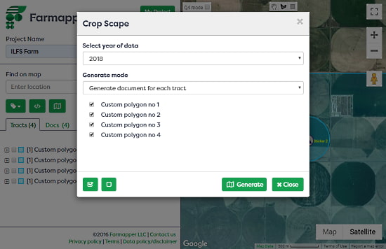
Crop Scope is another useful feature of this app that no other mapping app offers. This feature allows you to create custom sections on the map for different crops. Instead of having just a single regular map, you can precisely describe the crop for particular areas along with the date to keep everything checked.
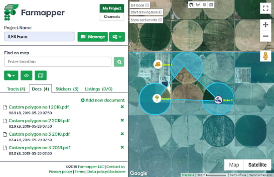
Once done, all this information added to the map in the form of documents under the Docs section next to Tracks. The map is saved to your Farmapper account and you can also export it as a KML file.
Give it a try here.
Wrap Up
Farmapper is a comprehensive mapping app for farmers and other agriculture needs that allows you to create a precise descriptive map of farms. The map can have legal land records along with all the agricultural data.