In this tutorial, we will learn How to Display Excel Data on Map: Excel to KML. As you may know, KML stands for Keyhole Markup Language. A KML file is an XML file format which is used to display the geographic data on a map. By following this tutorial, you can easily mark lots of places on a map rapidly and at once. For this tutorial, we will take data from an Excel file and convert it into map readable geographic data i.e. a KML file.
If you are looking for an easy and ideal solution for geocoding addresses in Excel, you can follow our tutorial, How to Geocode Address to Lat Long in Excel.
How to Display Excel Data on Map: Excel to KML?
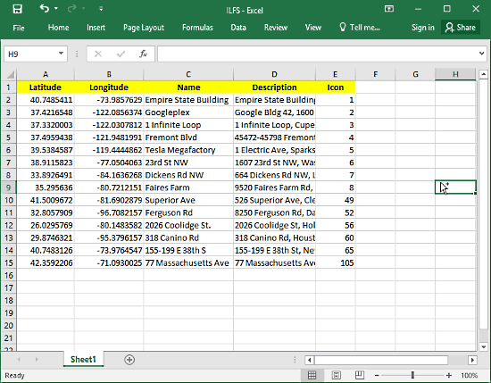
First of all, create an Excel file with latitude-longitude coordinates in the first two columns. Then you can add extra columns if you want, such as Name, Description, Icon etc. These extra columns are optional. I defined names of the place in the Name column and complete address under the Description column. The Icon column is just to show random icons on these locations which are pre-defined in Google Earth.
Excel to KML:
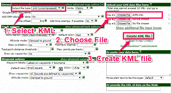
Once you finished your Excel file, its time to generate a KML file for it. For that purpose, go to this link. This website will convert your Excel to KML. You will find a lot of options on this website; don’t you worry about that. Just follow these three steps to convert Excel to KML.
- Select the output file type .kml(uncompressed). The other output format here is KMZ, which is a compressed version of KML. You can also use KMZ in place of KML. But, for the sake of simplicity and avoiding any confusion, let’s stick with KML here.
- Choose and upload your Excel file.
- Click on Create KML file to generate the KML file from your Excel file.
After that, this website will take you to a new page where you will find your KML file. Click on the KML file to download it.
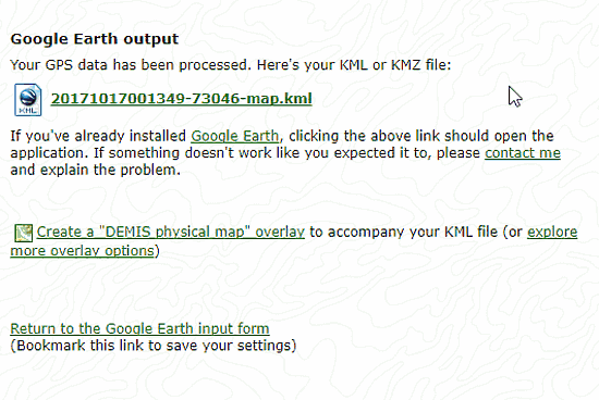
At this point, you successfully converted your Excel to KML. You have a KML file with the data from the Excel file.
How To Display Excel Data on Map?
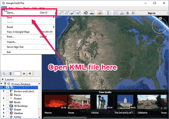
We are going to use Google Earth to display the data on the map. You can download Google Earth from here if you do not have it installed already. Open Google Earth and open the KML file in it. To open the KML file, go to File -> Open, and browse to the KML file.
Once you open the file in Google Earth, it will load in Places section under Temporary Places. You can see all the places you entered in your Excel file here. All these places will also be marked on the map with the names which you mentioned in the Excel file. You can hide any of these places from the map by unchecking them from the Places section.
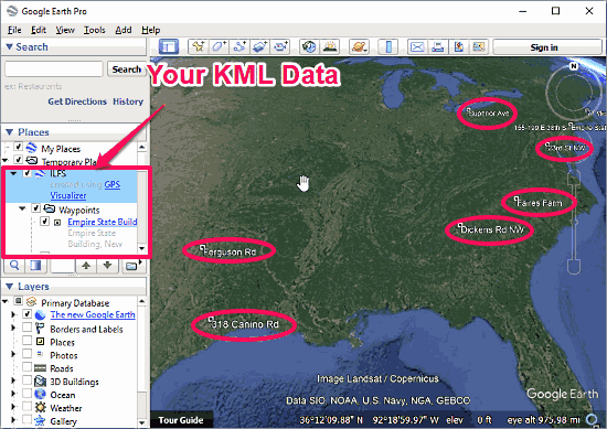
When you click on any of these locations on the map, a popup opens for that location which contains a description. This description is the Description text that you mentioned in the Excel earlier. You can see the preview of the same in the image below.

Verdict:
With the help of this tutorial, one can easily map large number of locations on the map. This short tutorial is easy to follow and saves you a lot of time. Give it a try and share your experience with us.